dallen 3w ago • 100%
I’ve been mostly a poetry guy but have tested out uv a bit lately. Two main advantages I see are being able to install Python (I relied on pyenv before) and it’s waaay faster at solving/installing dependencies.
dallen 3w ago • 100%
In VS code these should work through the Remote-Containers flow, just like they do through Remote-SSH.
dallen 3w ago • 100%
I have to use macOS at work and I sorely miss the efficiency and simplicity of gnome.
I’ve spent a lot of time configuring and tweaking various DEs in the last 20 years, but somehow gnome shell nailed it for me.
Happy to have many options as a Linux user!
dallen 3w ago • 100%
It’s very minimalist and the project ditched the Windows-style approach some years ago. Personally, I’ve grown to love it and other DEs feel bloated now.
To each their own 🤷♂️
dallen 2mo ago • 100%
Hmm, I just re-read the blog post and GitHub where I thought I read that and I think I was mistaken…
dallen 2mo ago • 100%
Poetry support is on their roadmap!
dallen 2mo ago • 83%
I was gonna say, I don’t like to victim blame but why would people be grubbing around these days to begin with?
dallen 3mo ago • 100%
Ansible is so simple yet so elegant.
dallen 3mo ago • 100%
My company only requires that I run their AV agent (bit defender).
Microsoft Teams is even flakier than on Windows (yes, it’s possible…)
dallen 3mo ago • 100%
It’s not a dealbreaker for me but I feel your pain. Getting everything organized in Gitlab is a pleasure.
dallen 3mo ago • 100%
This is not a subscription but a perpetual license and for my needs it’s already well worth the price they are asking. Using this actively with my wife but also sharing albums with about 8 other family members.
I find the no-subscription model very attractive and I’m open minded to companies trying out new software licensing approaches. I like the idea of the developers getting paid for their good work and being able to do it full time.
dallen 3mo ago • 100%
This just means that this project is still too early in development for you. The breaking changes happening in this phase are going to pay off in the long run and prevent the project from getting bogged down.
I would give it another shot when they release v2
dallen 3mo ago • 100%
I was in those masses. They sent me a free CD in the mail when I was a teenager!
dallen 4mo ago • 100%
Sometimes I use Drawing for adding some annotations but I mostly just paste directly from the screenshot tool.
In terms of editing, I work more with SVG where I use a very simple editor BoxySVG.
dallen 4mo ago • 100%
Yea, none of those things matter to me.
Don’t get me wrong, I’ve had plenty of fun customizing DEs but I don’t really need that on my daily driver. I also have more of a terminal based workflow so perhaps shell customization scratches that itch for me.
To each their own :)
dallen 4mo ago • 100%
One man’s “basic” things are another man’s clutter …
dallen 4mo ago • 100%
I personally also put Pydantic on the S tier.
Also, I use (geo)pandas on a regular basis and when it comes to geometric operations Shapely is an amazing library.
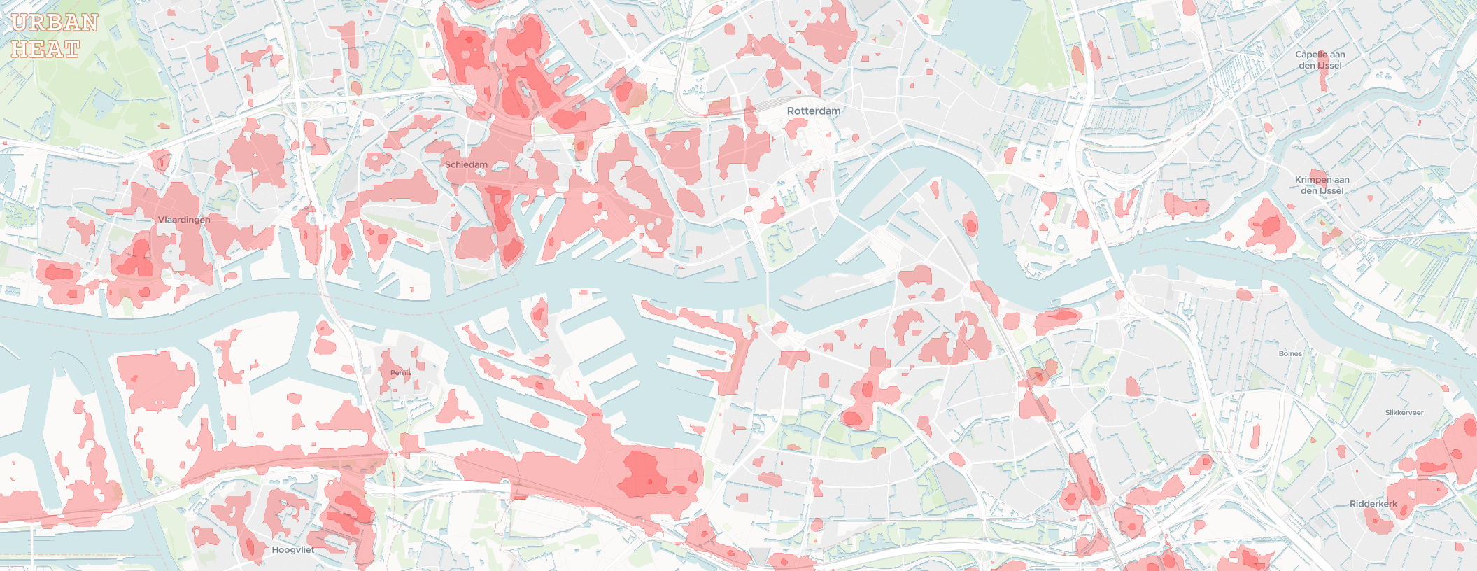
Repo: https://github.com/damienallen/urban-heat cross-posted from: https://programming.dev/post/14939898 > I wanted to share a small project I've been working on. The goal was to make the data from NASA's Landsat Thermal Infrared Sensor more accessible to the general public. > > I worked with the raw temperature band data to general annual maximum surface temperature raster images for large urban areas covered by the Eurostat GISCO Urban Audit. In the browser, these images are transformed into easier to interpret isotherm contours with some adjustable settings. > > I don't have a specific target audience in mind. The map could help identify areas of refuge for the warmer months, or overheated neighborhoods to avoid as we march towards a toasty future. > > Feedback is welcome :) > > > 
repo: https://github.com/damienallen/urban-heat cross-posted from: https://programming.dev/post/14939898 > I wanted to share a small project I've been working on. The goal was to make the data from NASA's Landsat Thermal Infrared Sensor more accessible to the general public. > > I worked with the raw temperature band data to general annual maximum surface temperature raster images for large urban areas covered by the Eurostat GISCO Urban Audit. In the browser, these images are transformed into easier to interpret isotherm contours with some adjustable settings. > > I don't have a specific target audience in mind. The map could help identify areas of refuge for the warmer months, or overheated neighborhoods to avoid as we march towards a toasty future. > > Feedback is welcome :) > > > 
 urbanheat.app
I wanted to share a small project I've been working on. The goal was to make the data from NASA's Landsat Thermal Infrared Sensor more accessible to the general public. I worked with the raw temperature band data to general annual maximum surface temperature raster images for large urban areas covered by the Eurostat GISCO Urban Audit. In the browser, these images are transformed into easier to interpret isotherm contours with some adjustable settings. I don't have a specific target audience in mind. The map could help identify areas of refuge for the warmer months, or overheated neighborhoods to avoid as we march towards a toasty future. Feedback is welcome :) --- EDIT: For UK visitors, sorry to leave you with an empty map... I've taken a look at older urban extent data and found the geometry I need to process the UK (from before leaving Eurostat). However, there are still some UI limitations to overcome since it seems that cities are split into many boroughs that could only be viewed one at a time. The reason I went with the Eurostat dataset to begin with was a nice delineation of what a city was (for the purposes of this project). Don't have a timeline, but I do want to add the UK and automatic loading of cities as you pan!